Attention!
Before you go digging please contact me. This is a very public place in a historic location. Also know that when the Chicago casque was found the searchers had already dug 6 holes to find it. They wrote a letter to Preiss who replied with a photo of the patted down earth of where the casque was buried. Even then they almost missed it and were about to give up. It was buried 18 inches down – which is fairly deep. I don’t want to see this place or the hunt ruined by being reckless. Just being off by an inch can mean making a big hole and coming up empty. If you have experience with ground penetrating radar, that would be a huge help. Thanks for understanding.
The following is my interpretation of the solution to image 11 / Verse 3. A great deal of ground work toward the solution has already been done, and can be found here: pbworks the secret image 11 Since this information is already widely known, and publicly available, I have filtered the information down a bit and added a large amount of my own interpretation to make a coherent case. Some nonessential aspects of the image are not explained here. Also note that this is my interpretation, and as with any interpretation, it can only be validated with the actual casque – which has not been unearthed.

General Observations and Thoughts
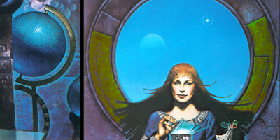
At first glance, Image 11 raises many questions:
- Who is this red-headed woman?
- Why is there a globe and stand in the image?
- What are the lines in the main circle? Numbers?
- What do the moon and celestial object (star or planet) represent?
- What do the squiggly lines on her dress and the box represent?
- What is her index finger pointing to?
- Why is there a fairy flying away from the box that she is opening?
The answers to these questions are all significant to solving the puzzle. Solutions that do not answer these questions, or recognize their importance, miss out on the author’s clues. While they are not all critical to solving the puzzle, they do add depth and reinforce the correct interpretations.
Before I get started, I would like to point out two general themes in the image. It is important to note the fairy flying away from the box in the woman’s hands. There are 4 references to the fairy embedded in this puzzle. Also note that “truth” has 3 separate references in this puzzle, as I will show as we go. For that matter, Image 11 itself is chock-full of these sort of things. Boston, being one of America’s most iconic/historic cities, has an abundance of possible locations and connections to references in this puzzle. It is easy to interpret meaning and make connections to locations that are not related to finding the casque. This makes it especially important to see the layers of meaning for each step of the solution. They will help assure us that we have chosen the right path. Also each physical location that we arrive at from the verse is roughly 100-200 yards apart. They are evenly spaced and consecutive locations along a walking path.
Connection to Charlesgate and Back Bay Fens

Assuming we have already made the connection to Boston, we have a few clues in the image that we should be in the Back Bay Fens/Charlesgate area. The most prominent is the map and note, seemingly emanating from a crack in the stone to the right of the woman. The pathways of the map bear resemblance to the Massachusetts Turnpike, Boylston St, and the Berkelee College of Music. There is also a more subtle reference to John Boyle O’Reilly in the image. While many people see a ‘112°’ written in the flower petals to the bottom left of said map. I believe that this actually reads ‘212°’, as 212° is the boiling point for water. This is a reference to John Boyle O’Reilly, and the many locations named after him in the area. The position of the ‘212°’ imagery with respect to the ‘map’ is geographically consistent with the John Boyle O’Reilly Memorial, Boylston St, and the Boylston Section of the Victory Gardens, i.e. it is southwest of the other items on the map. Looking more at the image for confirmation, the base of the first ‘2’ in ‘212°’ is visible but the hook of the ‘2’ is not so easily seen. I enhanced the colors of the image and do see a faint but distinct color difference where the hook of the ‘2’ should be, indicating that JJP did intend to paint this part of the image as a number ‘2’. The enhanced color, position of the imagery, and geographical correlation combined make sense as a reference to John Boyle O’Reilly. There is a ‘3’ written into the negative of the woman’s hair just left of the ‘212°’. I think this ‘3’ actually relates to the shape of the docks in Boston Harbor (this can be seen on the pbworks wiki) and is unrelated to the Boyle reference.

The Red-headed Female Columbus

We know the area, now where do we start? To begin to understand this puzzle we must first look at, and correctly interpret, four aspects of the image before we can fully understand the first two lines of the verse. I know, this sounds like a lot, please bear with me. The foremost aspect of the image, the woman, was modeled after the Christopher Columbus statue in the Christopher Columbus Waterfront Park. Another strong reference to Christopher Columbus is in the lower right quadrant of the image. The sphere (or globe) is held by a stand that forms the shape of his initials: “CC”. The image of the globe itself, is also a reference to Columbus, in that it is/was the popular belief that Columbus proved the Earth was round.

There is a third, more subtle reference to Columbus in the form of his initials “CC” drawn in the lower half of the main circle (shown above), and there is a very small checkmark inside the initials at about 3 o’clock. After weeks of pondering its meaning, I believe it is to be interpreted as “Check or CC” i.e. “Check or Credit Card” – the common question at a point of sale. In other words, it is there to reinforce the interpretation of the initials as “CC”. This is rather cryptic and I am not positive of its interpretation. However, I think this scenario is plausible, and it does make sense toward the puzzle, even if it is a bit tongue-in-cheek.
While there are many historic places in Boston that commemorate Columbus, it is important for this puzzle to understand who we are looking at. The fact that we are looking at a red-headed female version of Columbus is significant.
The Sons of Ireland

Next, we take a look at the heart and feather in the circle directly above the woman. The heart and feather (quill pen) represent the Sons of Ireland, “Courage” and “Poetry” respectively, from the John Boyle O’Reilly Memorial, located on the northeast corner of Mother’s Rest at the intersection of Boylston and Fenway. Note that the statues are not visible from Google street view, as they face west-southwest looking into Mother’s Rest. If we were to overlay the face of a clock onto the large circle in the image, then the “Sons of Ireland” would be located at twelve o’clock.

Furthermore, using the homophone of “son” as “sun”, we might think of this as an allusion to solar noon (i.e. when the sun is at twelve o’clock). However, we see a moon and star in the image which implies nighttime (and would make the interpretation of noon a paradox). But if we continue along this same train of thought – twelve o’clock at night is midnight – we get “midnight sun”. Midnight sun (when the sun is visible 24 hours a day) can only be seen from locations within 1 degree of latitude of the Arctic Circle, which defines a very narrow and specific geographical range. The author gives us a hint that this is the correct interpretation by the addition of the image of – 1° – immediately to the left of the Sons of Ireland. The “midnight sun” and 1° imagery also fall within the main circle of the image, which is consistent with a reference to the Arctic Circle. In short, the top of the circle can be read: “One degree, midnight sun, in the Arctic Circle”. For the purposes of this puzzle, the nordic countries of Iceland and Norway are included in this range. Think “Land of the midnight sun”.

Putting it Together with the Verse
The first two phrases of Verse 3 read:
If Thucydides is
North of Xenophon
Take five steps
In the area of his direction
This text alludes to Horace Walpole, and specifically a letter he wrote to Horace Mann in 1774: “The next Augustan age will dawn on the other side of the Atlantic. There will, perhaps, be a Thucydides at Boston, a Xenophon at New York.” While the text itself is significant in helping associate verse 3 to Boston, it is the author, Horace Walpole, that is the key to this piece of the puzzle. Horace Walpole is famous for coining the term “serendipity” for which he used to describe a fairy tale: “Three Princes of Serendip”. Note the “fairy tale” aspect (fairy reference #1).
Reviewing our hints thus far:
- We have a red-headed Christopher Columbus, along with the 2 other pieces of Columbus-related imagery.
- There is a strong reference to a location where there is a midnight sun.
- And we have the concept of serendipity.
Who is this person? Leif Erikson. Leif Erikson is the red-headed “Christopher Columbus” from the land of the midnight sun. He was the son of Erik the Red (he had red or reddish hair), sailed from Iceland (land of the midnight sun), and his voyage to, and subsequent discovery of, North America (Vinland as he referred to it) was one of the most serendipitous events in the recorded history of exploration. He was so serendipitous (for this, and other additional reasons) that he acquired the nickname “Leif the Lucky”. The kicker is that our search for Christopher Columbus was, in and of itself, serendipitous, as instead of finding Columbus we found Erikson. We should also note that the storyline behind these puzzles is about the journey of the “Fair” people from the Old World to the New World. It is no coincidence that this fair-skinned explorer, having discovered the New World himself, appears on the cover of the book.

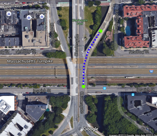
But why is Leif Erikson portrayed as a female? That is where we make the connection to a real place: The Leif Erikson statue in Charlesgate. Here is another link: publicartboston.com The statue is very effeminate with two large circular breastplates and chainmail that ends just above a mini-skirt. It is certainly in stark contrast to how we normally think of norse explorers of the time.
This statue in Charlesgate is just yards away from the Massachusetts Turnpike. Below is the Leif Erikson statue with respect to our other landmarks.

Finally, after all of that we can begin!
Once we make the connection to the Leif Erikson statue, the second phrase of the verse becomes clear:
Take five steps
In the area of his direction
The Leif Erikson statue is purposely positioned facing west to represent his voyage westward. Five steps west from the Leif Erikson statue puts us on the curb of Charlesgate East.

From here we can see the path to our next location. The verse says:
A green tower of lights
In the middle section
Unlike the metaphorical and hidden nature of our starting location, this phrase is to be interpreted literally. As we walk up the on-ramp to the Bowker Overpass we can see the “Green Monster” at Fenway Park in the distance.


We are given a visual hint that this is part of our intended path by the image of the “CC” globe stand (again). Right around the time that we can see Fenway Park in the distance, if we look down over the side of the on-ramp we see Charlesgate Park below. The stone and concrete benches in Charlesgate Park match the “CC” shape in Columbus’ initials. This view and positioning of the “CC” globe/stand in the image is important with respect to our cardinal direction. We are currently walking south across the Bowker Overpass and this feature in Charlesgate Park matches the alignment in image 11 only if we are facing south and looking down. As a side note, I think the actual shape of these benches forms the initials “CG” for Charlesgate, but were tailored in the image to show “CC”. This is the northerly aligned google maps view for comparison.

The next phrase of the verse reads:
Near those
Who pass the coliseum
With metal walls
This phrase tells us to use the Bowker Overpass to cross over the Massachusetts Turnpike. The coliseum refers to Fenway Park, and ‘those with metal walls’ are the people (on the Turnpike) behind the metal walls of their cars. It could also mean that the coliseum itself has metal walls, and that we are walking near cars that have passed, or will pass Fenway Park on the Massachusetts Turnpike.
Face the water
Your back to the stairs
Feel at home
The word “turnpike” is another word for a winding staircase. This definition comes from Sir Walter Scott, nonetheless, and is first written in The History of Scotland. Scott is a key reference in the NYC puzzle (Image 12). Searchers have been looking for a literal staircase that matches this phrase for years. However, this is wordplay. The reference is a homonym and not a literal staircase. Since we have just passed over the Massachusetts Turnpike, Preiss is telling us to face the water (Muddy River) with our back to the Massachusetts Turnpike. “Feel at home” refers to the song “Dirty Water” by the Standells. “Dirty Water” in this case is a metaphor for the Muddy River. The current intersection of the Bowker OverPass with Boylston Street is different than it existed in 1981. In those days it appears that a pedestrian would need to walk east along the street before being able to cross over (without jaywalking) near Mother’s Rest. This lines us up nicely with the Muddy River and Turnpike and it also takes us close to the Sons of Ireland statue mentioned earlier. I used the satellite imagery at historicaerials.com from 1971 as it is the most clear. However, the 1978 imagery also shows this layout.

All the letters
Are here to see
“All of the letters” in this case refers to the names of the footpaths through the Fenway Victory Gardens in Back Bay Fens. Each path is assigned a letter.

Eighteenth day
Twelfth hour
Lit by lamplight

I have two interpretations of this phrase, and I am not sure which one was the author’s intended interpretation. Both involve Paul Revere. The phrase itself refers to Paul Revere’s midnight ride. My original thought was that this phrase alludes to the lamps lit in the Old North Church tower to signal the nature of the arrival of the incoming British army. “One if by land. Two if by sea.” The lamps were lit by the sexton of the church, Robert Newman. I thought this was another wordplay for “sextant” (sexton => sextant) – as the overhead view of the George Robert White Fund Memorial – Veterans Memorial Park resembles the shape of a sextant. I will discuss this in the next section. However, there is a second interpretation regarding Paul Revere and lamplight. “Lit by lamplight” may not refer to the midnight ride, but to an obelisk that Paul Revere built on Boston Common in 1766 to celebrate the repeal of the Stamp Act. The obelisk was illuminated from within by 280 oil lamps. The obelisk burned down when it caught fire from said lamps. This is a more obscure reference, but it could be that it is an allusion to the obelisk at the war memorial. In our next step we will be standing in front of the obelisk. A third possibility is that it could also be a reference to the War of 1812 using “eighteenth” and “twelfth”. In any case, the major imagery in Image 11 represents features around the war memorial and Kelleher Rose Garden. These are further along the Emerald Necklace trail that we are already on, and in the direction that we are walking. The purpose of this verse is to take us there.

The Sextant
Now that we are at the war memorial, we must tie together several aspects of the puzzle to find our dig site. First, lets take a look at the imagery for the war memorial itself. The overhead view of the war memorial resembles that of a sextant, an instrument used for celestial navigation (sun, moon, stars) – credit Edmund Tannini. While there is no evidence that the sextant existed in the time of Columbus or Erikson, we do have a running theme of sea fairing explorers.

Furthermore, we see the moon, and either a star or a planet behind the woman. This suggests celestial navigation, and reinforces the interpretation of the use of the war memorial as a sextant. The profile of the woman’s head and hair against the blue (nighttime) background also match the overhead layout of the inner circle of the war memorial. We are supposed to gather that we are looking at the moon and star through the telescope lens of a sextant. And the center of the war memorial is our scope. That is, we are to use the inner circle of the war memorial as a line-of-sight guide to our dig site.
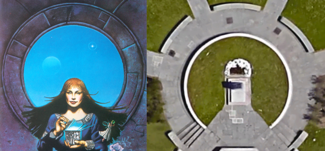
If we use the markers of the outer circle of Image 11 to align the celestial objects, and apply this to the layout of the war memorial, a path is revealed (shown below). It shows us that we are to use the path on the left, a westerly path, as a line-of-sight to our final location. I overalyed a 360 degree protractor on the image as there was some debate as to whether we were to use actual measurements in degrees. However, it is highly unlikely that Preiss used such exact measurements from an overhead perspective. I believe the intent was to simply draw lines through the celestial objects.

Note: I believe the celestial object next to the moon is the planet Venus. Venus (goddess of love) was portrayed with red hair in the iconic painting “The Birth of Venus” by Sandro Botticelli, which is consistent with the hair color of the woman shown. We also see the moon next to this object. This limits our candidates to stars and planets that generally intersect the earth’s plane of orbit. It also exlcudes other well-known celestial objects like Polaris, “The North Star”, as the moon and Polaris are never in the same field of view.
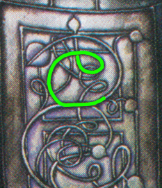
The Rose Garden
Before I reveal our final location, we have a lot more information we can gather from the puzzle to assure us that our path is correct. We know we are to go west from the war memorial, which is in the general direction of the Kelleher Rose Garden. The keyhole shape of the garden itself is the largest piece of matching imagery in Image 11 comprising the overall shape of the painting.

Her skirt has another match to the rose garden – an ornate pattern of sections and squiggly lines which has previously been identified as being visually similar to stonework in the Kelleher Rose Garden (right). Looking closer at the design on her skirt (below), we see a distinct pattern used in tying a clove hitch – a type of knot (shown below). Taking this reference together with the uses of the Kelleher Rose Garden and all of the rest of the interwoven lines, we can interpret this to mean ‘tying the knot’ or ‘getting hitched’, as the Rose Garden, with its scenic setting, is a common place for weddings.

The Map
Further analysis of the pattern on the woman’s skirt reveals similarities with the overhead-views of the war memorial in the 70’s and 80’s. Note the clove-hitch pattern has a second use as it represents the shape of the hedgerows at the war memorial during this time period.
Please keep in mind that this is a photo from 1971, a full decade before the casque was buried. The 1978 photos of this location show the same features, but the resolution is very poor.

Continuing the analysis on the pattern on her dress against the 1971 satellite imagery, a map of the location at that time is revealed (shown below). Note that the mapping of these objects on the woman’s dress is not to scale or proportionately accurate. The objects’ placement is mostly accurate with respect to their relative position to each other. If JJP had painted an accurate-to-scale map of Image 11, this puzzle would have been solved long ago. However, the image obscures the map enough that it is really only visible to those that study the location. It is important to see that the location of the trees with respect to the walkway is consistent, as is the position of the mini-garden above the rose garden. The clove-hitch-styled hedgerow is not between any of the trees, but it does sit at the southeast corner.

- Rose-red: The large sphere in front of her right leg (to our left) represents the circular shape of the north end of the Kelleher Rose Garden.
- Blue: The right and upper borders of the pattern represent the concrete walkways/sidewalks.
- Green: We see several small leaf-like nodes hanging off of the lines/vines. These are elm leaves. Elm leaves are asymmetrical, obovate to ovate, abruptly pointed, toothed leaves. There are other trees in the area but Preiss has labeled the elm trees for us in the map.
Elm leaf – note the asymmetry and tip (Wikipedia) - Darker Green: The top-most leaf/node on the map is outside of the border. It represents an elm tree that stood on the north-side of the sidewalk, near the street. It has since been cut down.
- Orange: In the top left corner of the pattern on her dress there is a small circle with a line going through it. This represents a small garden patch just north of the Kelleher Rose Garden.

Many of these features still exist today.
The symbols running downward along the sides of her skirt are also part of a map of the surrounding area. The most ostensible are the double ‘A’ shape, which represents the shape of the walkways west of the Kelleher Rose Garden. Along with the two checkerboard patterns representing the bridges across the Muddy River to the southeast and southwest of the KRG. Below is a complete interpretation of these symbols with an associated legend.


In Truth Be Free

The last phrase of Verse 3 “In Truth Be Free” identifies the dig site. This too has layered meaning. First, lets look at the fairy flying away from the box. She has been identified as representing “Faith” In the painting The Red Cross Knight by John Singleton Copley (fairy reference #2). This is a depiction of a scene from the epic poem The Faerie Queene by Sir Edmund Spenser. The Red Cross Knight himself represents “Truth” (truth reference #1), while the other woman, in blue, represents “Hope”. With respect to Image 11, Faith (the fairy) is flying away from the box as if she is being freed. The overall keyhole shape of Image 11 reinforces the verse, in that the keyhole shape represents a lock. In essence, Truth (the knight) unlocks the box that sets Faith (the fairy) free.

There is an allusion to a second story embedded here. In the story of Pandora’s Box all of the evil flies out of the box leaving only Hope inside (fairy, albeit indirect, reference #3). If we have already made the connection to Faith through The Red Cross Knight, then it is noteworthy that the character Hope is not seen in the image. We might think of Hope as still inside the box. As such, the image of the casque itself is a reference to Pandora’s Box. I think the illustration of the woman opening the box, and the light emanating from within, illustrate this conclusion.
The Box

The box itself has the same squiggly/knot pattern as the one that appears on her skirt. We can assume that this pattern represents marriage (or a place where people get married). To the right of the knot we see a castle with the sun peaking out over the top right (north northeast). The castle itself has been identified as a reference to The Castle at Park Plaza, while the sun has been identified as the circular pattern in the walkways of Statler Park – across the street to the northeast. If we look at a map of the area and attempt to line up The Castle and Statler Park where Statler Park appears just over the Castle to the north northeast, we see that these locations align on Columbus Ave. From this vantage point, the knot pattern aligns with the Boston Public Gardens. This makes sense, as it, along with the Kelleher Rose Garden, are two of the top public wedding venues in Boston. In the image below the left section marked ‘A’ is a color coded image of the box. The middle section ‘B’ is the colored box being held by the woman. And ‘C’ is a color coded map of the area. The colors represent the matching elements between each section. See the legend below.

- Bright green: The squiggly lines, representing Boston Public Gardens (where people get married).
- Blue: The castle, representing the Castle at Park Plaza.
- Yellow: The sun, representing Statler Park.
- Red: The woman, representing Columbus Ave, our vantage point to align these locations.
The woman herself (our red-headed Columbus) represents the Columbus Ave vantage point which we are to use as our “north”.
What is she pointing at?

If we look closely, the woman’s left index finger is pointing at part of the knot on the box. It appears to be at the lower region of the box, which would represent the lower region of the Boston Public Gardens from our vantage point. The most prominent feature in this area of the gardens is the George Washington monument.

Taking this into consideration we look for clues that this in indeed a reference to George Washington. A closer inspection of the squiggly knot shows a distinct pretzel shape just above the woman’s fingertip. This shape is a representation of George Washington’s signature. The image below shows the highlighted area of the knot that doubles as the ‘G’ in Washington’s signature. Note the distinct and recognizable pretzel shape at the base of the G. Keep in mind that this was a very small portion of Image 11, and I have increased the size 500% to highlight this feature.

The Washington Elm
There is a second visual indication of George Washington in the image. If we examine the perched falcon, we find the bird’s shape matches the the roads and sidewalks around Flagstaff Park, Cambridge Common, and Massachusetts Ave. The pig outline is to identify Harvard’s Pig Club which is right at the base of the bird in the profile of its claw. The Pig Club (Porcelain Club) is located at 1324 Massachusetts Ave. The ‘T’ is the Red Line Terminal nearby. The square table top is Harvard Square. The bubble is the circular Revolutionary War memorial next to the Washington Elm. The bird’s tail splits at the end just like Mass. Ave splits in two. There is also a tunnel that goes down underground in Flagstaff Park. The long straight feather in the birds tail is similar to the shape of the road as it goes into the tunnel.


The Washington Elm in and of itself does not really stand as a hint for this puzzle. But! The Washington Elm was first popularized by the American writer Henry Wadsworth Longfellow. Longfellow wrote Paul Revere’s Midnight Ride, The Masque of Pandora, and The Evening Star. These three stories are all major pieces of this puzzle. So by placing a bubble in the image that represents the area adjacent to the Washington Elm, Preiss is hoping we will make the connection between Henry Wadsworth Longfellow, the Washington Elm, and the themes of this puzzle. That is how we know this is a critical hint. This hint also ties George Washington to a tree, which will come into play later. There are elm leaves in the map on her skirt as well.
The Sheraton Commander

Just north of the Washington Elm is the Sheraton Commander. Its large sign can be seen from all around Cambridge Common, and is very visible from the Washington Elm. The Sheraton Commander was named after the event in which George Washington took command of the American army under the elm tree. So George Washington is the commander that it is referring to. Knowing this we look to the image to see if we can find something referencing this iconic location. In image 11 at about 7 o’clock in the main circle there is some hidden writing. We can make out “SHE” and “CAMBR” for “Sheraton Cambridge”

I realize that this is very hard to read, and for about 3 years I thought it was gibberish. However, as the pieces started to fall into place with George Washington and the Washington Elm I have recently realized this was also part of the map around Cambridge Common.

The Reveal
Taking everything into account:
- The sextant at the war memorial, and the line-of-sight perspective from the war memorial itself
- The map of the area west of the war memorial on her skirt
- The contextual map of the elements around the Kelleher Rose Garden
- Pandora’s Box
- George Washington’s pretzel shaped ‘G’ signature used in Boston Public Gardens
- The Washington Elm in Cambridge Common
- The Sheraton Commander (named after Washington) in Cambridge Common
- “In Truth be Free” Truth is needed to solve the puzzle
We find that our dig site is a cherry tree of the species Prunus ‘Pandora’*, which is visible directly after the westerly concrete walkway from the war memorial. Why a cherry? There is the old myth about Washington and the cherry tree. The story goes that Washington, as a boy, chopped down a cherry tree. When confronted by his father Washington said: “I cannot tell a lie, I did it with my little hatchet” (truth reference #2). Instead of punishing Washington, his father praised him for telling the truth. The phrase “in truth be free.” is also a line in the song Ode on Washington’s Birthday “Let our land in truth be free.” (truth reference #3). Furthermore, Washington D.C. is well known for its cherry blossoms in the Spring.
Attention!
Before you go digging please contact me. This is a very public place in a historic location. Also know that when the Chicago casque was found the searchers had already dug 6 holes to find it. They wrote a letter to Preiss who replied with a photo of the patted down earth of where the casque was buried. Even then they almost missed it and were about to give up. It was buried 18 inches down – which is fairly deep. I don’t want to see this place or the hunt ruined by being reckless. Just being off by an inch can mean making a big hole and coming up empty. If you have experience with ground penetrating radar, that would be a huge help. Thanks for understanding.
*Note I am still waiting on confirmation that the cherry tree is of this species. Prunus Pandora were widely planted as ornamental cherry trees on streets and in parks in the past. Nowadays, they have been replaced by other cultivars, but the age of this tree is at least 44 years old, and lends it to being within the time period that they were popular. I will update this post when I get confirmation.


The tree can bee seen below in the 1971 view from historicaerials.com


The fairy’s dress maybe symbolic of a cherry blossom. There might also be a cursive ‘C’ ( for “Cherry”) written in the knots.


did you ever look for it?
LikeLike
I haven’t been able to travel to Boston. I was hoping to go this year, but it may not happen. Because it is in a very public place, I want to try to identify the exact spot before digging. At minimum a soil probe, but ideally ground penetrating radar. I plan to ask the Emerald Necklace Conservancy.
LikeLike
FYI, the Emerald Necklace Conservancy cannot grant permission to probe/dig, you would need to contact Boston Parks Dept. I have another location that I wanted to probe, however Boston Parks Dept. said that it was not allowed………
LikeLike
Thanks, and I removed the other thread
LikeLike
Thanks for sharing your work! Here’s what I came up with for the Charleston casque: https://jamesvachowski.com/2017/12/31/the-buried-treasure-of-sullivans-island/
LikeLike
Thanks! I didn’t see this. I haven’t ever looked at this one. I will give it a read.
LikeLike
I’m literally just back from Boston, but I’ve been mostly walking around the 2C site, never went that far. Also, someone keeps digging in between the 2Cs, but I’m quite sure that even if that’s the right place, it would be rather on a side
LikeLike
It is not there.
LikeLike
I haven’t been an avid Secret solver myself, just happened to be in Boston and I recognized the CITGO sign, the Greem Monster wall, so just kinda paid my tribute to the amout of time the people invested into solving it. Wish I’ve stumbled on your theory before, could have taken some extra pictures
LikeLiked by 1 person
I live in Boston, right on Fenway, about a 10 minute walk to the area you’re talking about. I wouldn’t mind checking it out sometime soon. The ground is pretty solid right now, but things should thaw soon!
LikeLike
Thanks! If you can get some photos I would greatly appreciate it.
LikeLike
I agree with you on this location, however I have a different spot that I would like to probe. My wife and I have been to site a few times now to take a look around and we believe we have made some connections to the image. One is of the shadow cast by her neck and the rivers edge near the foot bridge (much more noticeable in person than google earth); https://imgur.com/08HqZ9M. Another possible connection is to the women’s left shoulder and the left shoulder at the WWII monument (at least we think i looks similar); https://imgur.com/2TKhclm. The last one has to do with a bird perch located near the rose garden; https://imgur.com/C8Pz1gS & https://imgur.com/Wgpv2YE. We have found out that the bird perch is for a red tailed hawk family, however based on information from the Emerald Necklace Conservancy, it was installed in 2010 (but who’s to say it wasn’t a replacement). Unfortunately we were denied permission to probe from the Boston Parks Dept.
LikeLike
Have you ever verified with GPR? Considering a trip and getting some friends to go in on the rental in order to confirm. I’m a botanist so can narrow down the species identification for this tree. It sounds like the Boston Parks department has denied more than one request to dig. Any tips on how/not to approach them? If I managed to verify with radar, there would be much less disturbance, do they need to give permission for surveying with radar or just for digging?
LikeLike
Hi Danielle thanks for your interest. GPR may not be useful for the Back Bay. The entire park is made of construction fill, which contains a mix of small, medium, and large rocks including junk/waste/concrete that was just mixed in when they created the park. In the grassy areas where the trees are planted, there are a few inches of top soil, after that it is almost all mixed rocks. This is because BBF floods often, and the ground needed to be strong but porous to allow water to drain. Even using a simple soil probe is nearly impossible because there are so many false positives. Many of the rocks are far bigger than the casque itself. The BPD was quite curt in their response and they are not approachable on the matter. A friend of mine was not even granted a conversation with them. He was an engineer and did the research and even pulled up the old architectural plan prints of the park some 100 years ago. I have an updated post with tons more information on the site including specifics, but I have only shared it privately. I have reason to believe the casque is buried a full 3 feet down. I am in a pickle because I can’t share the info publicly, or someone will probably lay waste to the site. I have a long term game plan I am working on, which includes another angle. I have been to Boston twice this year, and the best part about it was the city. If you go, I recommend going for the sights, don’t spend money on GPR until you have been there. I don’t think anyone would care if you surveyed it, Boston is pretty relaxed. But I don’t think GPR will be fruitful. I wish I could share more information. I will in the future. Also BBF is super seedy at night, be careful.
LikeLike
Hi Julian, that is quite a pickle and also explains why no one has been able to move on this yet. I’m familiar with the problems of fill, but I had forgotten that Back Bay is built on almost nothing else. I certainly don’t want to harass park staff or anything, nor spend money on a nearly useless detector.
If you need another type of assistance, I spent many years living in Boston, I have friends currently living there and visit regularly. Do you still need a species ID confirmed for that cherry tree? That at least is in my bailiwick. I got very excited about these puzzles and would like to help, but the scale of the undertaking is staggering, so I’ll settle for a small contribution.
Next time you go, try the $0.50 oyster special at The Red House in Cambridge, 12pm to 6pm daily your first dozen oysters are $6 and after that they are $1 each. It’s the best oyster deal I’ve found in the city.
LikeLike
Yes! I do need help identifying the cultivar. I was there twice, and I am a gardener but I couldn’t identify it. I have asked the Olmstead Tree Society twice and got a reply but never got the answer.
I don’t like holding information, that is one of the reasons I started this blog was because the information on the pbworks wiki was censured. I believe the casque is there, and I think it is 3 feet down. I don’t own the casque, so if you are intent on going after it, go for it. For me, GPR probably isn’t helpful anymore, that is because of the terrain and there seems to have been at least 3 separate attempts to dig around the tree in different places in the past. So even if a GPR showed the ground as disturbed we wouldn’t know when. Plus there are some huge subterranean rocks there. I also believe I know the exact location.
LikeLike